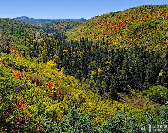
64 6/10 Road near Vega State Park, Collbran, Mesa County, CO, 9/23/2011
Looking up this wooded creek canyon in west central Colorado on the first day of fall, I found my first hint of colorful autumn foliage! Just as striking is the river of pines that flows along the creek bed at the base of the canyon. These are Colorado blue spruce (Picea pungens), a type of pine that flourishes in the sheltered moist conditions where a creek flows. A few of the conifers have taken hold on the hillsides but do not grow as tall as their downhill companions. We're about 7,540 feet above sea level in Plateau Creek Canyon looking south, with Swede Flats and Campbell Mountain up the hill to our left and Kirkendall Flats up the hill to our right. At center and into the distance, we're looking up Leon Creek Canyon, through which flows the river of pines. The trees pause near the lower right where Leon Creek flows into Plateau Creek 120 feet below us. As far as I could tell, both creeks are dry in September. The distant summit at far left is Salt Peak (elevation 9,804 feet), part of the bluish horseshoe shaped ridge extending to the center of our view. The ridge is the source of East Salt Creek in Grand Mesa National Forest. This land was once the swampy shoreline of a vast inland sea during the Paleozoic era. The swamps were filled with sea creatures including giant sea turtles whose fossilized remains can still occasionally be found here!